-
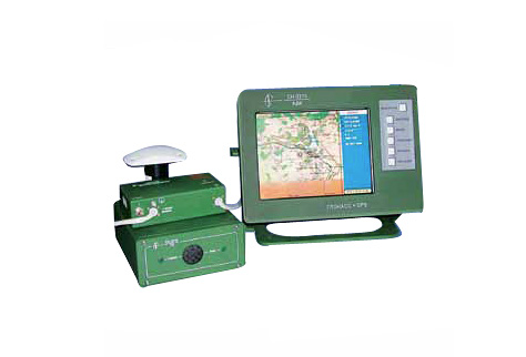
СN-3210 Navigation system of survey and time provision is mounted in dedicated ground facilities and intended for the following problem solving:
- determination of on-line navigation parameters of objects and current time;
- displaying the navigation parameters of objects on the digital ground chart;
- integrated processing of navigation and cartographic information;
- maneuver planning and remote monitoring of object maneuver execution;
- on-line navigation information exchange with interacting objects;
- initiation, storage and displaying the chart in selected scale (from 1:100 to 1:5000000);
- displaying, registration and control of objects on the chart of selected scale;
- elaboration of differential information at control and correction station (CCS) operation.
SPECIFICATION
24 receiving channels:
Positional/altitude accuracy
- in off-line mode (RMS):Operating temperatures:
DME (display and monitoring equipment)
antenna:Operating increased humidity:
DME:
antennaDimensions DME:
Weight DME:
Power supply:
Power consumption DME:
Interface:
- two input-output ports RS232/422
Built-in and remote antenna.GPS/GLONASS/SBAS, L1-range
Algorithm of receiving channel selection
All-in-view10/15 m
from -20° С tо +50° С
from -50° С tо +50° С98 % at 25° С
100 % at 25° С377х277х170 mm
5,0 kg
DC 10-30 V
30 W
RS232/422
Каталог
- Сухопутні війська
- Флот
- Повітряні сили
- Протиповітряна оборона
- Аерокосмічна галузь
- Засоби РEБ
- Обладнання зв'язку
- Mobile Ground Radio Jamming System Forthe Communication And Air Control Links «liman»
- Field Voice Telephone TA-01
- Digital Telephone DTA-04
- Handheld 2 W VHF Tactical Radio R-002
- Manpack VHF Tactical Radio R-005
- HF Tactical Radio R-1150
- Mobile VHF Tactical Radio R-030
- Relay Station R-450
- Router A-201
- Fielder Cross-connecting Module KP-351
- Radio Gateway R-1261
- Path Switching and Multiplex Equipment K-1301 (PSME)
- VoIP Gateway K-1220
- Ethernet Switch A-101
- Digital Cable Modem M-101
- Charging Unit ZP-11
- Digital Cable Modem Ethernet M-1201
- Charging Units C-1001 and C-1002
- Charging Unit C -1004
- Digital Field Digital Field Telephone Switch K-1210
- Digital Automatic Communication Switchboard System (DACS) K-201
- Tactical Terminal A-9620
- Container for Integrate Communication Facilities
- Basic Information and Communications Package (BICP)
- Complex Communication Facility (CCF)
- Command Vehicle (CV) K-1450
- Network Management "Sinevir"
- Command & Control Information System "Narada"
- Radio Set R-130M Yag1.021.029
- Transceiver R-143
- Transceiver R-163-10K
- Transceiver R-163-50k
- Radio Set R-173
- Receiver R-173PM Yag1.021.029
- Equipment of Integral Connection and Commutation (Vehicle Intercom System) R-174T
- Communication Helmet ТSH4-U
- Combined Radio Set R-142NE
- Field Telephone ТА-57-U Yag 2.180.000
- "Kushetka-B"
- Radio Set "Berkut-M" for 1.201.015
- GPS and/or GLONASS Jammer Kupol-1
- Transceiving Ultra Wide Band Antenna
- Mobile Phone Jammer Gsm Blocker "voyage 0819"
- Mobile Phone Jammer Gsm Blocker "voyage 0918"
- Board Receiver of Satellite Navigation (BRSN)
- Private Use Navigation Receiver "CN-3003M"
- Navigation System of Survey and Time Provision "CN-3210"
- Integrated Satellite Navigation Equipment “CN-3307”
- Device of Frequency Time Synchronization “CN-3841”
- Flight Management System АСМ 05 “CN-4311”
- Board Equipment of Satellite Navigation “CN-4312”
- Navigation and Geodetic Two Frequency Equipment “CN-4601”
- Receiving Module GPS/GLONASS/SBAS “CN-4701”
- Wideband Low Noise Amplifier 3-millimeter Range Wave-length Arka.434815.078
- Digital Radiorelay Station (DRRS) “Oksamit”
- Onboard Computer A-5010
- Міліція та спецзагони
- Підготовка особового складу
- Газотурбінні електростанції
- Надлишкове військове майно