-
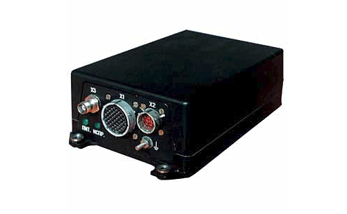
BRSN is 24 channel GLONASS / GPS / SBAS Class C1 navigation receiver for use in integrated assemblies of airborne equipment in Civil Air Transport.
BRSN is used as an information system, navigation parameter sensor, for problem solving in en route navigation, terminal area, nonprecision approach and categories 1, APV1, APV2 approach.
Automatically and continuously in real time scale the receiver finds and outputs location coordinates, altitude, three vector components of flight relative speed, the current UTC time, etc. to related systems.
Specification
GPS/GLONASS:
Accuracy:
- for coordinates
- for altitudeUpdating rate:
RAIM function
RAIM prediction:
Interference resistance:
Operating temperatures:
- RCU (receiving and computing unit):
- antenna, amplifier:Supply voltage:
Power consumption:
Dimensions: antenna:
RCU:
antenna amplifier:
Weight RCU:
Information reception and output:
- according to ARINC429:
- onetime commands:L1 range.
10 m,
15 m. 10 Hz(FDE algorithm).
up to 24 hours.
according to KT3401 and SARPS, Appendix 10 for separate reception of GPS and GLONASS.
from 40° C to +55° C
from 55° C to +85° C
27 V
15 W
119,4x73.6x59 mm
244x140x73mm
147,5x70x21mm
more than 2,31 kg
7 inputs / 3 outputs;
9 inputs / 2 outputs.
Каталог
- Сухопутні війська
- Флот
- Повітряні сили
- Протиповітряна оборона
- Аерокосмічна галузь
- Засоби РEБ
- Обладнання зв'язку
- Mobile Ground Radio Jamming System Forthe Communication And Air Control Links «liman»
- Field Voice Telephone TA-01
- Digital Telephone DTA-04
- Handheld 2 W VHF Tactical Radio R-002
- Manpack VHF Tactical Radio R-005
- HF Tactical Radio R-1150
- Mobile VHF Tactical Radio R-030
- Relay Station R-450
- Router A-201
- Fielder Cross-connecting Module KP-351
- Radio Gateway R-1261
- Path Switching and Multiplex Equipment K-1301 (PSME)
- VoIP Gateway K-1220
- Ethernet Switch A-101
- Digital Cable Modem M-101
- Charging Unit ZP-11
- Digital Cable Modem Ethernet M-1201
- Charging Units C-1001 and C-1002
- Charging Unit C -1004
- Digital Field Digital Field Telephone Switch K-1210
- Digital Automatic Communication Switchboard System (DACS) K-201
- Tactical Terminal A-9620
- Container for Integrate Communication Facilities
- Basic Information and Communications Package (BICP)
- Complex Communication Facility (CCF)
- Command Vehicle (CV) K-1450
- Network Management "Sinevir"
- Command & Control Information System "Narada"
- Radio Set R-130M Yag1.021.029
- Transceiver R-143
- Transceiver R-163-10K
- Transceiver R-163-50k
- Radio Set R-173
- Receiver R-173PM Yag1.021.029
- Equipment of Integral Connection and Commutation (Vehicle Intercom System) R-174T
- Communication Helmet ТSH4-U
- Combined Radio Set R-142NE
- Field Telephone ТА-57-U Yag 2.180.000
- "Kushetka-B"
- Radio Set "Berkut-M" for 1.201.015
- GPS and/or GLONASS Jammer Kupol-1
- Transceiving Ultra Wide Band Antenna
- Mobile Phone Jammer Gsm Blocker "voyage 0819"
- Mobile Phone Jammer Gsm Blocker "voyage 0918"
- Board Receiver of Satellite Navigation (BRSN)
- Private Use Navigation Receiver "CN-3003M"
- Navigation System of Survey and Time Provision "CN-3210"
- Integrated Satellite Navigation Equipment “CN-3307”
- Device of Frequency Time Synchronization “CN-3841”
- Flight Management System АСМ 05 “CN-4311”
- Board Equipment of Satellite Navigation “CN-4312”
- Navigation and Geodetic Two Frequency Equipment “CN-4601”
- Receiving Module GPS/GLONASS/SBAS “CN-4701”
- Wideband Low Noise Amplifier 3-millimeter Range Wave-length Arka.434815.078
- Digital Radiorelay Station (DRRS) “Oksamit”
- Onboard Computer A-5010
- Міліція та спецзагони
- Підготовка особового складу
- Газотурбінні електростанції
- Надлишкове військове майно